A Walk through Peekskill – McGregory Brook

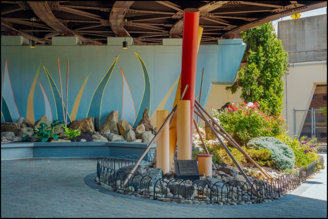
I was walking back down it was much easier going down than going up) along Central Ave. to catch my train I heard the sound of running water. I looked across the street and noticed a pocket park with a couple of benches, and an information board (see below). In case you can’t make out the rather small text it reads:

McGregory Brook flows from the hills just east of Peekskill to the Hudson River at Riverfront Green Park. Kitchawank people, of the Wappinger confederacy, inhabited the area surrounding McGregory Brook and nearby Annsville Creek prior to Dutch settlement, led by Jan Peeck.

King William III of England granted 1,500 acres to Hugh MacGregorie in 1692, and the brook became the boundary between the original settlement known as Peekskill and surrounding Van Cortlandt lands. Numerous mills and factories diverted McGregory Brook for power, including Dain’s Lumber Company, Naylor Brothers machine shops, Mackellar’s Mills, and Union Stove Works. For many years, Peekskill residents drew water from the Tan Yard Spring, which also surfaced near this site.

Today, McGregory Brook enters a series of culverts at Field Street, flows beneath Downtown Peekskill, and emerges just east of this site. Remnants of industrial infrastructure can still be seen from the footbridge overlooking the waterfall.

Although McGregory Brook is no longer visible on most maps, FEMA’s 100-Year Flood Map clearly shows the pathway of McGregory Brook from Penelope Pond to the Hudson Riverfront. The lack of sunlight inhibits the brook’s natural ecosystem. While few fish, amphibians, or aquatic invertebrates inhabit the brook, filamentous green algae thrives on its surfaces, likely supported by nutrient enrichment from stormwater runoff and other sources.

For more information about Peekskill’s waterways and all of its natural features, explore the Peekskill National Resource Inventory at www.peekskilnri.com. For more information on Peekskill’s rich history, visit the Peekskill Museum at 124 Union Avenue.


Taken with a Sony RX10 IV

A Visit to Boston – Day Two – Norman B Leventhal Park

According to the park’s website:

“In the heart of the financial district, nestled among the high-rise office buildings, lies a lush oasis of green, a testament to the ingenuity and creativity of a group of people, both public and private, who joined together to foster this unique vision. What had previously been a decrepit and unsightly garage, is now an award-winning and inviting park set above a new underground parking garage. The Norman B. Leventhal Park is supported, structurally and financially, by Garage at Post Office Square, a 1,400-space parking garage.’

The Urban Land Institute describes it as follows:

“The 1.7 acre park’s centerpiece is a walk-through sculptural fountain, so whimsically friendly that in the summertime, office workers eating lunch often kick off their shoes to dip their feet in the fountain. A few yards away is a 143-foot-long formal garden trellis, supported by granite columns, draped with seven species of vines. The jewel-like Great Lawn, raised above the walkways by a granite curb, provides a relaxed retreat. More than a hundred different species of plants, flowers, bushes and trees are within the park. It features custom wrought-iron fencing and specially designed drainage gates. Seating styles fit every posterior and mood – stately teak benches, curving steel settees, movable cast-iron café chairs with tables, hundreds of linear feet of inviting polished granite wall and half an acre of lawn, all meticulously maintained” (Urban Parks and Open Space, Urban Land Institute, 1997).

My Canadian friend had some business with a US bank so we walked around looking for it. Eventually we found it and she went in. While we were waiting, we sat in the park and talked. After a while a guy came up and spoke to us. Apparently, he was from Sudan. At first the conversation was fairly innocuous, but after a while he accused us of “not respecting” him and started hurling abuse at us. Thankfully, he walked away at that point. At that point we needed a change and moved to another part of the park, where there was a pleasant cafe (Sip Cafe) with an outdoor seated area where we waited until my friend had finished her business.


Taken with a Sony A6000 and 18-135mm f3.5-5.6 OSS

Croton Aqueduct in Art

In an earlier post I mentioned Cornela Cotton and her book store/gallery (See: Cornelia). I also mentioned that she was going to give a presentation organized by the Briarcliff Manor-Scarborough Historical Society on “The Croton Aqueduct in Art”.

She gave the presentation to an almost full house at Briarcliff Manor’s Vescio Community Center. It was very well received.

Note that I don’t have a copy of her presentation, or the exact images she used so the pictures below, although similar are for illustrative purposes only.

For a really good overview of images of the Old Croton Aqueduct see The Project Gutenberg eBook of Illustrations of the Croton Aqueduct, by F. B. Tower.


Taken in mid April 2023 with a Sony A7IV and Rokinon/Samyang AF 24-70 f2.8 FE

A walk around Dobbs Ferry – Overview

A while back I went for a walk around the Hudson River Town of Dobbs Ferry. Above view of the Dobbs Ferry Metro North Station from the other side of the the tracks.

“Dobbs Ferry is a village in Westchester County, New York, United States. The population was 10,875 according to the 2010 United States Census. In 2019, its population rose to an estimated 11,027. The village of Dobbs Ferry is located in, and is a part of, the town of Greenburgh. The village ZIP code is 10522. Most of the village falls within the boundaries of the Dobbs Ferry Union Free School District.

Dobbs Ferry was ranked seventh in the list of the top 10 places to live in New York State for 2014, according to the national online real estate brokerage Movoto. Dobbs Ferry is also the first village in New York State certified as a Climate Smart Community and was granted in 2014 the highest level given out in the state.

Multiple groups of native peoples lived in what is now known as Dobbs Ferry since at least 4500BC. The most recent tribe who claimed territory of the area are the Wecquaesgeek, maintaining villages up until the 1600’s. Numerous artifacts from the tribe continue to be found along Wicker’s Creek in oyster middens.

Dobbs Ferry was named after Jeremiah Dobbs, a descendant of William Dobbs, of Swedish and Dutch ancestry whose family ran a ferry service that traversed the Hudson River at this location. Dobbs was a fisherman and settled near the southern part of what is now Dobbs Ferry, and he “added to his meager income by ferriage of occasional travelers across the Hudson. He used a style of boat known at that day as a periauger, a canoe hollowed out of a solid log. . . From this primitive ferry the village took its name.”

Dobbs Ferry played a vital role in the American Revolutionary War. The position of the village opposite the northernmost end of the Palisades gave it importance during the war. The region was repeatedly raided by camp followers of each army; earthworks and a fort, commanding the Hudson ferry and the ferry to Paramus, New Jersey, were built; the British army made Dobbs Ferry a rendezvous, after the Battle of White Plains in November 1776, and the continental division under General Benjamin Lincoln was here at the end of January 1777.

In July and August 1781, during the seventh year of the war, Continental Army troops commanded by General George Washington were encamped in Dobbs Ferry and neighboring localities, alongside allied French forces under the command of the Comte de Rochambeau. A large British army controlled Manhattan at the time, and Washington chose the Dobbs Ferry area for encampment because he hoped to probe for weaknesses in the British defenses, just 12 miles (19 km) to the south. But on August 14, 1781, a communication was received from French Admiral Comte de Grasse in the West Indies, which caused Washington to change his strategy. De Grasse’s communication, which advocated a joint land and sea attack against the British in Virginia, convinced Washington to risk a march of more than 400 miles (640 km) to the Chesapeake region of Virginia. Washington’s new strategy, adopted and designed in mid-August 1781, at the encampment of the allied armies, would win the war. The allied armies were ordered to break camp on August 19, 1781: on that date the Americans took the first steps of their march to Virginia along present-day Ashford Avenue and Broadway, en route to victory over General Cornwallis at the Siege of Yorktown and to victory in the Revolutionary War.

The village was originally incorporated in 1873 as Greenburgh, but the name was changed to Dobbs Ferry in 1882.

The Estherwood and Carriage House, Hyatt-Livingston House, South Presbyterian Church, and United States Post Office are listed on the National Register of Historic Places. (“Wikipedia).

Taken with a Fuji X-E3 and Fuji XC 16-50mm f3.5-5.6 OSS II

Around the neighborhood – Trump National Golf Club Westchester

The Trump National Golf Club is just a short walk from the House.

Trump National Golf Club Westchester is a private golf club in Briarcliff Manor, New York. The 140-acre (57 ha) course has eighteen holes, with a 75,000-square-foot (7,000 m2) clubhouse. Founded in 1922 as Briarcliff Country Club, it later operated as Briar Hills Country Club and Briar Hall Golf and Country Club. Donald Trump, later 45th president of the United States, purchased the property in 1996 and renamed the club after its county, Westchester, in a similar manner to his other golf properties. He had the clubhouse and course rebuilt for its 2002 reopening; the course was designed by Jim Fazio. Donald Trump served as president over Trump National Golf Club LLC (managing the Westchester club) from August 2000 until January 19, 2017, the day before his inauguration.

The club had its origins around 1895, with Briarcliff founder Walter W. Law’s private nine-hole course on his estate, which became available to Briarcliff Lodge guests, and was then known as the Briarcliff Golf Club. In 1922, Devereux Emmet designed a course across the street with eighteen holes, and thus Briarcliff Country Club was founded that year. The name was changed in 1927 to avoid confusion, to Briar Hills Country Club. Briar Hills opened in May 1929 with a new clubhouse; construction began in May 1928 and utilized local stones for the building’s exterior. The interior was noted for its design and spaciousness. In 1936, A. W. Tillinghast redesigned the course. In 1948, Henry Law’s son Theodore sold the club to local businessmen who renamed it Briar Hall Golf and Country Club. The 1964 Metropolitan Open was hosted at Briar Hall; Jack Patroni won the championship. In 1980, ownership of the club changed hands again.

Henry Law, a son of village founder Walter W. Law, was among Briar Hill’s founders. Among the club’s directors were Henry Law and his son Theodore Gilman Law; Gene Sarazen was the club’s golf professional in 1923–24, followed by 1952 PGA Champion Jim Turnesa.

At the time of Briar Hall’s 1996 sale, the club had an 18-hole, 6,313 yards (5,773 m) golf course and 78,782 square feet (7,319 m2) clubhouse, seven tennis courts, an in-ground swimming pool, pro shop, maintenance building, and pool house.Briar Hall had been taken over by the Marine Midland Bank, which then sold the property to Trump (Wikipedia)

Taken with a Panasonic Lumix GF-1 and Lumix G Vario 45-150mm f4-5.6