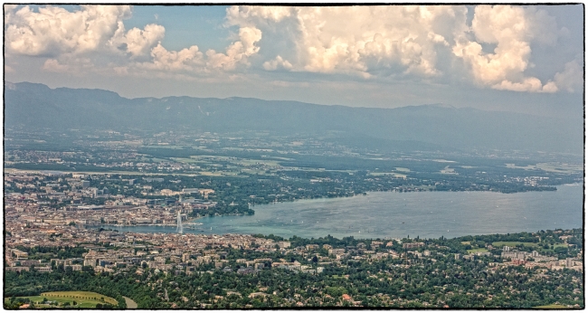
Chronologically this picture was taken towards the end of our visit. I’ve decided to include it here because it gives a good orientation to Geneva for those not familiar with the city.
It was taken from the top of Mont Saleve, which is actually in France. In the background you can see the Jura mountains, which at this point are also in France. In between is Lake Geneva going off to the right. In the left foreground is the City of Geneva with its famous fountain (the Jet d’eau) visible in the picture. On the far left of the picture River Rhone runs out of the lake, having earlier run into the lake in the Swiss Canton of Valais. From this you will infer correctly that Geneva is almost totally surrounded by France.
Looking down the Rhone from the center of Geneva the city divides into two parts: the left bank (Rive gauche on the near side of the lake in the picture) and the right bank (Rive droite on the far side of the lake). The left bank contains many of the shopping areas as well as the old town, the opera house, the symphony hall, the Parc des Bastions; Parc des Eaux Vives; Park La Grange, Jardin des Anglais etc.). The right bank houses the UN complex, the railway station, the bus station, and the Botanical Gardens. The airport is also on this side of the lake.
We lived in (or near) Geneva for eight years. Unfortunately this coincided with a time during which I had largely lost interest in photography and I seem to have only a few pictures from this period. We visited Geneva in 2010 and 2011 and I have some pictures from these visits – mostly from the Rive Droite. Our daughter lives in one of the villages close to the foot of Mont Saleve and somehow I spent most of my time during this visit on that side of the lake i.e. Rive Gauche so pretty much all of this years’ pictures come from this area.

